


I don’t quite get this. The human head, like the globe, is not flat. Shouldn’t that be reflected in the projections? When projecting the earth in Mercator, we see the whole earth, not simply a “profile” of earth. I would expect a projection of a head to include the whole surface of the head, not a simple profile. How is this actually factual?
This is a better example
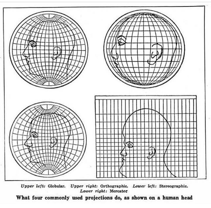
This isn’t representing projections of a human head. This is representing projections of the globe if the globe had a giant human head drawn on it instead of the continents.
But then you have to figure out how to transfer the drawing of the head onto the curved surface, and how you do that is going to determine how the projections look.
No, you can ignore that part. The image isn’t showing how to accurately draw a head onto a surface, it’s showing how this given head drawing would look in different projections.
Projections from what? You don’t need a projection for a drawing, it’s already a 2d image.
Edit: I realize that you can use it to compare the different projections to each other, but it doesn’t show which one is more accurate overall. In this image it looks like they used the globular projection as the "default’ with the most realistic drawing, and created the others based on that, but they could have picked any one of them to be the default.
Yes, again, that’s the point.
It assumes the sphere projection is correct, and shows how each of the 2D projections isn’t correct. This isn’t hard.
This has got to be wrong. A human head, projected like a world map, would show both eyes and both ears, except in the case of showing only one half (like when you only show/photograph the Americas).
This appears to take a picture of the side of the head (i.e. that particular projection, showing less than half of the full globe), then distort it as if it were already a different projection.
Edit: worse than that. The globe onto which the half-head-image is superimposed in the top right is larger than the head. Like if you took a photo of the Americas half of the world from space, pasted that onto a larger beach ball, then stretched the result to demonstrate the projections.
For a better visualization of how a human would look on the mercator projection, look no further than old games’ 3D textures, like this one from Half Life: https://www.textures-resource.com/fullview/6384/?source=genre
Potion seller. I’m going into battle and I need your strongest potions.
You can’t handle my strongest potions traveler
OK, now show us the Goode homolosine equal-area projection human head.
I would, but I have a weak stomach.
So how about the Cahill Butterfly projection, …
Came here to say this, but you did, so I’ll ask for the Dymaxion projection.
I’d say that people who like the Cahill butterfly have bad taste, but then again, I might be projecting.
Unlike the human head, the earth actually is nearly spherical. There’s got to be some differences in how spherical projections work when the object actually is a sphere, I would think. I know that 2D maps are distorted, but are globes actually this distorted as well? Never knew that, if so.
Edit: After reflecting on it for a minute, I see they’re demonstrating forms of 2D map distortion. The way depth is represented is variable. With modern concepts of 3D imagery, we must have solved this distortion problem. If you open up Google Earth’s globe, it doesn’t have such distortion.
With modern concepts of 3D imagery, we must have solved this distortion problem.
? You’re still taking a three dimensional earth and displaying it on a 2d screen or plane. That will always have distortion on some axes. That’s not a technological “problem” to be “solved”, that’s just mathematical reality.
Yes, that’s my point, we have computers that can pretty accurately represent depth, not like the old projections we drew on maps. Stretching it out flat (zooming in on google earth) has less distortion than these projections shown here, don’t they?


